Posts

Showing posts with the label Assignments

The Moon and the Tides

Image
People who live near the coasts are familiar with the periodic rise and fall of the oceans we call the tides .  The tides are caused by the gravitational force of attraction of the moon and the sun.  The highest high tides and lowest low tides are called spring tides.  They occur about twice a month near the full and new moon phases. In these events, the sun, moon, and earth are all aligned. When the sun and the moon are at right angles at the first quarter and last quarter phases, the changes in tide water level are smaller.  These smaller tides are called the neap tides. NOTE: Exam is scheduled for Tuesday, November 23, 2010.  You will need to bring the following items to the test: Pencils Calculator Earth Science Reference Tables Bring all items to the test with you and get 5 extra points !  Please review the study sheet handed out on Friday and do your best to prepare for the test.  See study topics listed below in the November 13 postin...

Weather Systems

Image
We are just completing the unit on weather. Tuesday we will have a test. Study your notes and read your review book. Homework : Due Tuesday, May 11, 2010 Review Book: read pages 167-172. Do Chapter review questions Part B2 and Part C, questions 21-47, pages 181-183.

Locating Positions in New York State

Homework # 5:  Using the Generalized Bedrock Geology Map of New York State, found in the Earth Science Reference Tables, identify the locations and coordinates given in the handout, Locating Positions New York State

What are Meteors and Meteorites?

Image
Our Solar System has countless chunks of rocky planet making material floating around in space between planets. Many of them orbit within the asteroid belt between Mars and Jupiter. Others have strange orbits which sometimes come close enough to cross Earth's orbit. And some of those which cross Earth's orbit actually enter the Earth's atmosphere and burn up. We call these meteorites. The streak seen as the particle burns up in the atmosphere, is called a meteor. If there is anything left after the trip through the atmosphere and it strikes the ground, it is called a meteorite. Tuesday, September 15, 2009: We will do a reading exercise differentiating meteors from meteorites. We will also be taking a quiz on the material covered so far. Study the vocabulary words we did for homework and be ready to differentiate an objective from an inference. En Español Haremos una lectura que analiza la diferencia entre meteoros y meteoritos. También, vamos a tomarnos una prueba sobr...

Words Used in Science Inquiry and Testing

Image
Our objective this Friday was to use terms commonly found in science inquiry and testing. Our classwork involved describing two mineral samples through the use of science inquiry. For homework, we will examine the meaning of these words. Homework #1 : Due Monday, September 14, 2009 Define the following words: Describe Compare Contrast Infer Analyze Explain Write the definitions in your notebooks. We will review the definitions on Monday.

Constructing and Interpreting Topographic Map Profiles

Image
A profile or cross-sectional view shows the shape of the landforms depicting the elevation differences along a particular area of land. Topographic profiles are easily made using graph paper and the method illustrated in the figure shown here. Note that profiles need to have both a horizontal scale and a vertical scale. A profile is easily constructed across a contour map by placing the bottom edge of a strip of paper along the section of the map one wishes to profile (see review book, page 24). At each point where the edge of the paper intersects with a contour line, mark on the edge of the paper. Record the elevation of the contour next to the mark on the edge of the paper. When all points are marked, use the vertical scale on the graph paper to place each point at its proper elevation and horizontal distance. Homework: Due Monday, November 16th Profile of contour map given in class on Friday. Due: Tuesday, November 17th Bring in earth science review book . We will review...

Phases of the Moon and Beyond

Image
The apparent shape of the moon depends upon the changing relative positions of the Earth, the Sun, and the Moon. This week we will take a close look at the phases of the moon as well as other astronomical features such as the planets of the solar system as well as the evolution of the universe. Homework : Due Friday, May 30th In review book: read pages 227-229, 238-242. Do questions 1-9 (page 230)and 34-44 (page 242).

Geologic Time Scale

Image
In the late 18th and 19th centuries, geologists in Europe discovered that rock formations could often be identified by the fossils contained in the rocks. Over the years, a relative scale of geologic time was created based on the fossils. The time units were based by the kinds of fossils and where they were found. However the exact age of the rocks would not be known for years to come. Homework : DUE FRIDAY, APRIL 18, 2008 In review book, read pages 121- 129. Review Chart on page 126-127; do questions 15-32, and 40-45 on pages 122-130. Provide full written responses to all questions.

Interpreting Earth's History

Image
Planet Earth formed about 4.6 billion years ago from an accumulation of rock, dust and gases drawn together by its own gravity. To unravel the mystery of our evolving planet from dust to the development of life, to the present, Geologist, like detectives, hunt for clues and evidence. There are several fundamental principles that guide geologists in interpreting and reconstructing the sequence of geologic events that have occurred throughout Earth history. The fundamental principles are: Uniformitarianism Superposition Original Horizontality Crosscutting Relationships (intrusions, folds, and faults) Fossils This week we will focus on the importance of fossils in the rock record and in establishing a geologic sequence. We will also look at how rocks are correlated or how we match similar rock strata in different locations to see if they formed at the same time or under similar conditions. HOMEWORK: due Wednesday April 9th. In review book (Thomas McGuire, 2nd edition), read pages 115-12...

Landscapes and Landforms

Image
This past week, we learned that a landscape is a region on Earth's surface in which various landforms, such as hills, valleys and streams are related by the common origin of weathering, erosion and deposition. The shape, or topography and composition of the landscape are determined by climate , local bedrock , geologic structures and human activities . This week we will examine the development of landscapes and see if we can distinguish between the characteristics of landforms. Our goal is to understand why climate and geologic structures play an important role in landscape development and to evaluate how human activities are influencing future landscapes. Homework : Due Thursday, April 3, 2008 Review Book: read pages 101-105, do questions 83-89, 95, 98, 101-102. Textbook: Students using the McDougal Littell textbook , read pages 290-292; Do question 4-5; draw the floodplain diagram on page 290; Compare this diagram to the stream diagram on page 288; According to these diagrams, ...

Rodinia: Supercontinent

Image
Thursday, March 6, 2008 is the end of the marking period. All laboratory reports and assignments are due no later than Thursday to receive credit for this marking period. Later submittals will be credited toward the following marking period. This week we will focus on two topics: Erosional processes; You can access the laboratory web-quest by clicking on the link Lab Investigation: Rodinia Super-Continent (Web-Quest) . Due Thursday, March 6, 2008 (last day of the marking period). Follow all directions and answer all questions . Erosion is the transportation of sediments by water, wind, or glaciers. The force of gravity drives most forms of erosion. Homework: Due Friday, March 7, 2008. Students using the McDougal Litell, Earth Science Textbook: read chapter 13.2, "Stream Erosion and Deposition", pages 283-286, Students using the Heath Earth Science textbook: read chapter 10, pages 168-171. In the review book, read pages 85-88.

Formation of Soils

Image
This week we learned about the process of weathering. Upon returning from our winter break, we will focus our attention on the formation of soil. Key Ideas: Soil is the mixture of weathered rock, microorganisms, and organic remains that usually covers the bedrock. Climate and other factors affect the composition of soil. Homework : Due Friday, February 29, 2008 (last day of the month). Students using the McDougal Litell, Earth Science Textbook: read chapter 12.2, " How Soils Form ", pages 264-266, and do section review questions 1-5 on page 266. Students using the Heath Earth Science textbook: read chapter 8, pages 138-140, 142, and do topic questions 7-11. In Reviewing Earth Science (all students), read "How Do Soils Form?" , pages 83-85 and do questions 17-23 on page 85. Quiz Friday, February 29, 2008. Beware it is Leap Year!

The Weathering Process

Weathering is the breakdown of rocks at or near the Earth's surface due to mechanical (physical) and chemical changes. The two types of weathering are as follows. Mechanical weathering takes place when rock is broken into smaller pieces without changing the chemical composition of the material. Chemical weathering takes place when the rock's minerals are decomposed or dissolved in solution and changed into different substances. Although mechanical and chemical weathering are studied separately, they almost always act together. Homework : Due Friday, February 15, 2008 In review book, chapter 4, read pages 81-82; answer questions 1-16.

Sedimentary Rocks

Image
This week we learned that most sedimentary rocks are composed primarily of the weathered remains of other rocks. Sedimentary rocks usually form by the compaction and cementing of sediment particles. We also learned that there are three types of sedimentary rocks: clastic (fragmental rocks), made up of different sized inorganic earth-derived particles; bioclastic (organic-derived), formed by the accumulation of plant and animal remains; crystalline (chemical) are deposited by chemical precipitation (settling) of materials from solution in seawater. This occurs during the evaporation of seawater and when compounds are no longer soluble. Fossils , the remains of prehistoric life, are almost always found in sedimentary rocks. Homework: In Reviewing Earth Science (Review Book) , by Thomas McQuire, do questions 32-44, on pages 41-42. Due Wednesday, February 6, 2008 Also, read pages 43-44 on metamorphic rocks . Do questions 45-52. Due Friday, February 8, 2008. There will be a test on s...

Mineral Groups - Major Silicates

Image
More than 90 percent of the minerals in Earth's crust are members of the silicate family. A silicate is a compound of silicon, oxygen, and usually one or more metallic elements, such as aluminum or iron. In all silicates, the basic building block is the silica tetrahedron, consisting of four oxygen atoms bonded to a central silicon atom. The mineral Quartz is made entirely of tightly bound silica tetrahedra. Quartz has the chemical formula SiO 2 . Homework : Due Thursday, Janaury 10, 2008 Textbook: Read Chapter-section 5.4, pages 108-111. Answer questions 1-4.

Types of Plate Boundaries

Image
This week we will redirect our attention at contrasting the differences among the three types of plate boundaries. Scientists classify boundaries between two plates according to plate movement. There are three main types of plate boundaries: divergent, convergent, and transform. Homework : due Thursday, December 20, 2007 Textbook : In chapter 8.2 and 8.3, read pages 176-181; do questions 1-7 on page 179. Review Book : In chapter 3, read pages 67-72; do questions 38-45, 52-57, on pages 70-72. En Español Esta semana resumiremos la naturaleza de los tipos de bordes de placa. Las placas litosfèricas se mueven como unidades coherentes en relación con las otras placas. Las placas tienen tres tipos distintos de bordes, que se diferencian en función del tipo de movimiento que exhiben. Los tipos de bordes son: Divergente, Convergente y Transformante.

Locating Earthquake Epicenters

Image
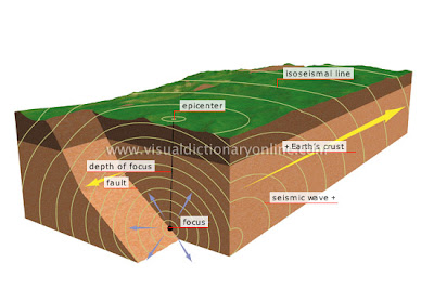
When an earthquake occurs, its energy radiates in seismic waves away from the focus as shown in the diagram above. These waves can be grouped into three categories: P-waves travel the fastest. These waves vibrate in a push-pull motion through the ground. S-waves vibrate in all directions perpendicular to the direction of travel. Surface waves vibrate in a push-pull motion as well as in all directions perpendicular to the direction of travel. These waves cause the most damage as they travel along Earth's surface. Homework : Due Thursday, December 13 th . Review Book : read pages 54-60. Do questions 1-16.

Types of Plate Boundaries and Causes of Plate Movement

Image
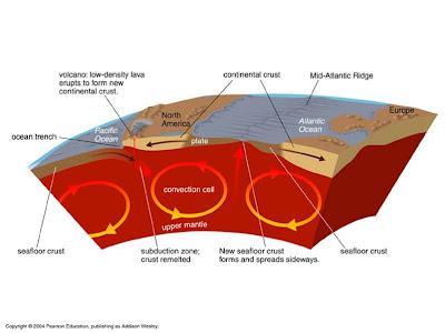
This week we will focus on contrasting the differences among the three types of plate boundaries . We will also discuss mantle convection as a possible cause of plate movements. Homework : due Thursday, December 5, 2007 Textbook : In chapter 8.2 and 8.3, read pages 176-181; do questions 1-7 on page 179. Review Book : In chapter 3, read pages 67-72; do questions 38-45, 52-57, on pages 70-72.

Week of October 29, 2007

We will continue working on the analysis and interpretation of topographic (contour) maps. This analysis includes but is not limited to the following: locating positions on Earth, using map scales, determining distance, constructing topographic profiles, and determining the gradient (slope) of an area. Please review the homework assignments for the week.

Assignment: Topographic Maps

Textbook : Read pages 53-57. Answer questions 1-5 on page 57.